|
|
|
|
|
|
|
|
truck
by jhix3734. 04/19/24 10:50 AM
|
|
|
|
1
|
2
|
3
|
4
|
5
|
6
|
|
7
|
8
|
9
|
10
|
11
|
12
|
13
|
|
14
|
15
|
16
|
17
|
18
|
19
|
20
|
|
21
|
22
|
23
|
24
|
25
|
26
|
27
|
|
28
|
29
|
30
|
|
|
|
|
|
|
102 registered members (jeffhhub, Bustinbeards, Jwbfx4, GomerPyle, auman, ts1979flh, BuckRidge17, Scout308, GHTiger10, BamaBoHunter, Ant67, Morris, DoeNut, Red Fox, Geeb, Ray_Coon, Remington270, Rolloverdave, ALDawg, Shmoe, Calvin, centralala, DoubleShoalsJR, BigEd, NoHuntin, Cactus_buck, kodiak06, dustymac, Floorman1, RidgeRanger, Mansfield, CouchNapper, mdavis, paintrock, CeeHawk37, Ron A., Chiller, johnv, rickyh_2, jake44, YellaLineHunter, bambam32, Livintohunt19, joe_g, thayerp81, top cat, CCC, Beak_Buster, JEM270, Joe4majors, gman, outdoorguy88, Dixiepatriot, cartervj, BhamFred, PourIron12, Rainbowstew, Reaper, Shane99, Austin1, MC21, Tupi, Bmyers142, Fullthrottle, dquick1, btfl, IMISSALDEER, MikeP, mossyback, Gunpowder, donia, bamaeyedoc, BentBarrel, hallb, Keysbowman, 4Him146, capehorn24, XVIII, 300gr, Ryano, jhardy, IDOT, 280MtnRifle, Antelope08, mzzy, M48scout, Narrow Gap, J_K, crocker, Tree Dweller, MCbama, Omega One, cullbuck, rrice0725, NorthFork, Marengo hunter, 6 invisible),
681
guests, and 0
spiders. |
|
Key:
Admin,
Global Mod,
Mod
|
|
|
 Old Alabama Maps
#2120858
Old Alabama Maps
#2120858
05/23/17 07:52 AM
05/23/17 07:52 AM
|
Joined: Sep 2009
Posts: 6,238
somewhere around 112.
slippinlipjr
 OP
OP
I make Calds fer a livin
|
OP
I make Calds fer a livin
Joined: Sep 2009
Posts: 6,238
somewhere around 112.
|
When I was a kid I used to draw maps of land I hunted. I still have some of em. I was pretty darn good at it. I look back on them knowing I probably couldn't do that today if I tried. Here's one of the earliest English maps I have seen. Every now and then I look at old maps and wonder how people 300 years ago were able to draw such detailed and fairly accurate representations of their knowledge of the land. Note that back then, they often used "f" in place of "s". Cabo river is the Cahaba. They also marked good hunting land on this map. If y'all are interested in perusing old maps of Alabama, UA has a great website. Old Halbama Maps [img:left]http:// 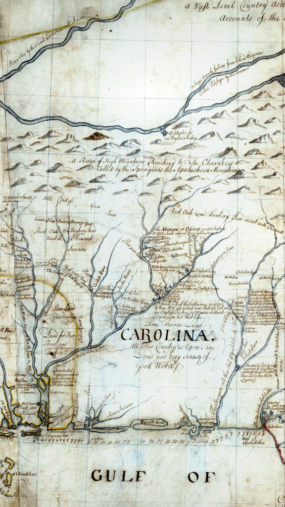 [/img] [img:left]http:// 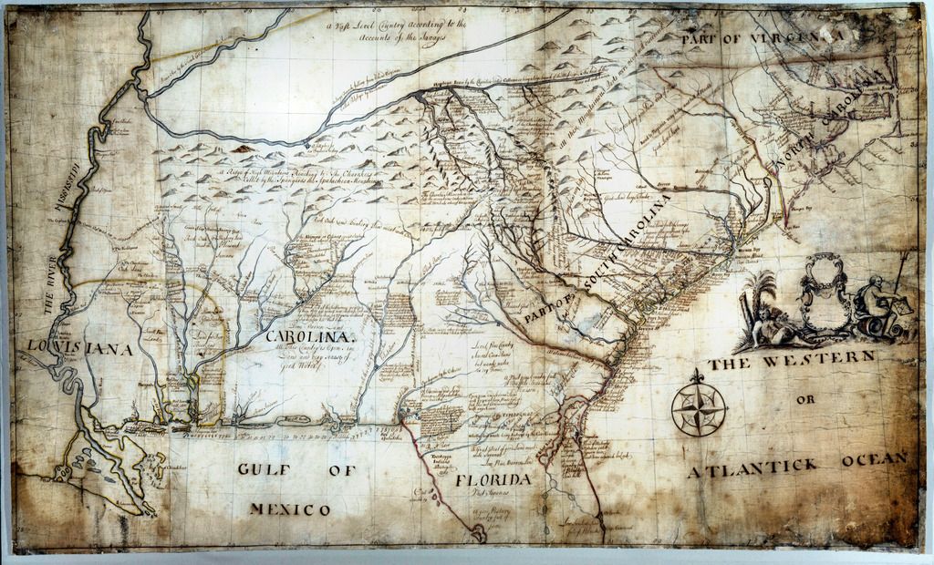 [/img]
|
|
|
Re: Old Alabama Maps
[Re: slippinlipjr]
#2120901
05/23/17 08:45 AM
05/23/17 08:45 AM
|
Joined: Jan 2016
Posts: 3,829
Chilton CO. Alabama
bama1157
10 point
|
10 point
Joined: Jan 2016
Posts: 3,829
Chilton CO. Alabama
|
That is cool, thanks for the link!!
The end of democracy and the defeat of the American revolution will occur when government falls into the hands of lending institutions and moneyed incorporation's Thomas Jefferson. 1812
|
|
|
Re: Old Alabama Maps
[Re: slippinlipjr]
#2120902
05/23/17 08:45 AM
05/23/17 08:45 AM
|
Joined: Aug 2001
Posts: 63,693
Luverne, AL
Skinny
GUVNER
|
GUVNER
Joined: Aug 2001
Posts: 63,693
Luverne, AL
|
Yup, thats a handy resource. Most folks on this site will really like the early 1900's soil maps of their where they hunt now.
Never Trust Government
"You can be broke but you cant be poor." Ruthie-May Webster
|
|
|
Re: Old Alabama Maps
[Re: 300gr]
#2121095
05/23/17 01:24 PM
05/23/17 01:24 PM
|
Joined: Aug 2003
Posts: 42,074
UR 6
top cat

Freak of Nature
|
Freak of Nature
Joined: Aug 2003
Posts: 42,074
UR 6
|
Cool. Part of one of the old indian boundries runs across our place.
LUCK:::; When presistence, dedication, perspiration and preparation meet up with opportunity!!!
- - - - - - - -A government big enough to give you everything you want, is big enough to take everything you have. Thomas Jeferson - - - - - - - -
|
|
|
Re: Old Alabama Maps
[Re: slippinlipjr]
#2121194
05/23/17 03:13 PM
05/23/17 03:13 PM
|
Joined: Dec 2013
Posts: 22,665
Lickskillet, AL
Irishguy
a.k.a. Dingle Johnson
|
a.k.a. Dingle Johnson
Joined: Dec 2013
Posts: 22,665
Lickskillet, AL
|
Read the Journal of Andrew Ellicott sometime. He set the the Ellicott stone which marks the 31st parallel between the Mississippi territory and the Spanish territory of the Florida panhandle. It is still the southern boundary of much of lower Alabama and Mississippi. It is amazing what he had to go through in the late 1700's to survey that line. We have a neat map topo map framed of the Rome quadrant that covers the area where our cabin is located up on Lookout Mountain. It was done in the late 1800's and it is interesting to see the locations of the old homesteads up near Little River Canyon and to see the Coosa river's path before it was dammed up to form Weiss Lake and to see where all the ferry crossings were. I love old stuff like that. Next time any of you are North of Creola, AL. on Highway 43 near Bucks, AL, pull off the side of the road and take a short hike off the beaten path and check out the Ellicott Stone. I found out through a few beers and a cigar on the back porch, that my buddy Skip had actually surveyed off of it back in the 1970's and says that it's location is remarkably accurate. https://en.wikipedia.org/wiki/Ellicott%27s_Stone Another interesting article about mounds along the line: http://blog.al.com/live/2010/02/surveyor_finds_old_mounds_mark.html"We were excited because we were finding them where I thought they would be," Denny said. "We were finding them to a 10th of a second of where we thought they would be. And they were surveyors and when they found them, they could recognize what they were."Facinating...
Last edited by Irishguy; 05/23/17 03:15 PM.
|
|
|
Re: Old Alabama Maps
[Re: Simpleman]
#2121363
05/23/17 05:38 PM
05/23/17 05:38 PM
|
Joined: Sep 2009
Posts: 6,238
somewhere around 112.
slippinlipjr
OP
I make Calds fer a livin
|
OP
I make Calds fer a livin
Joined: Sep 2009
Posts: 6,238
somewhere around 112.
|
Very cool! They missed the Choctahatcee and Pea altogether didn't they? My thoughts on that are back in them days, they didn't care to enter barren land.
Ctrl+C, Ctrl+V, Ctrl+Z
thesharkguard.com
|
|
|
Re: Old Alabama Maps
[Re: slippinlipjr]
#2121364
05/23/17 05:41 PM
05/23/17 05:41 PM
|
Joined: Sep 2009
Posts: 6,238
somewhere around 112.
slippinlipjr
OP
I make Calds fer a livin
|
OP
I make Calds fer a livin
Joined: Sep 2009
Posts: 6,238
somewhere around 112.
|
Very cool! They missed the Choctahatcee and Pea altogether didn't they? My thoughts on that are back in them days, they didn't care to enter barren land. Most of the panhandle of Florida is nothing but a big, deep pile of sand with stunted pines and turkey oaks on it. If it couldn't be farmed, they didn't want to advertise it.
Last edited by slippinlipjr; 05/23/17 05:42 PM.
Ctrl+C, Ctrl+V, Ctrl+Z
thesharkguard.com
|
|
|
Re: Old Alabama Maps
[Re: Irishguy]
#2121386
05/23/17 07:02 PM
05/23/17 07:02 PM
|
Joined: Dec 2012
Posts: 450
AL
ClarkGriswold
4 point
|
4 point
Joined: Dec 2012
Posts: 450
AL
|
Read the Journal of Andrew Ellicott sometime. He set the the Ellicott stone which marks the 31st parallel between the Mississippi territory and the Spanish territory of the Florida panhandle. It is still the southern boundary of much of lower Alabama and Mississippi. It is amazing what he had to go through in the late 1700's to survey that line. We have a neat map topo map framed of the Rome quadrant that covers the area where our cabin is located up on Lookout Mountain. It was done in the late 1800's and it is interesting to see the locations of the old homesteads up near Little River Canyon and to see the Coosa river's path before it was dammed up to form Weiss Lake and to see where all the ferry crossings were. I love old stuff like that. Next time any of you are North of Creola, AL. on Highway 43 near Bucks, AL, pull off the side of the road and take a short hike off the beaten path and check out the Ellicott Stone. I found out through a few beers and a cigar on the back porch, that my buddy Skip had actually surveyed off of it back in the 1970's and says that it's location is remarkably accurate. https://en.wikipedia.org/wiki/Ellicott%27s_Stone Another interesting article about mounds along the line: http://blog.al.com/live/2010/02/surveyor_finds_old_mounds_mark.html"We were excited because we were finding them where I thought they would be," Denny said. "We were finding them to a 10th of a second of where we thought they would be. And they were surveyors and when they found them, they could recognize what they were."Facinating... I had never heard of this Ellicott guy, so I looked him up tonight. He did several other significant projects in his day, like setting the western border of Pennsylvania, finishing off the western end of Mason-Dixon line after the war, and setting the boundaries of the new District of Columbia. He also took over and fixed several problems with Charles L'Enfant's design of the proposed new city of Washington in the DC. Jefferson also hired him to teach Meriwether Lewis before his expedition. Quite the career.
|
|
|
Re: Old Alabama Maps
[Re: !shiloh!]
#2121527
05/24/17 03:46 AM
05/24/17 03:46 AM
|
Joined: Dec 2013
Posts: 22,665
Lickskillet, AL
Irishguy
a.k.a. Dingle Johnson
|
a.k.a. Dingle Johnson
Joined: Dec 2013
Posts: 22,665
Lickskillet, AL
|
I saw on a discovering Alabama episode that Florida tried to sell Alabama the panhandle of Florida after the civil war for a million dollars. Alabama's reply was "why would we want to buy a goffer town "? The way I understand it, the people of the panhandle wanted in Alabama and the Alabama legislature wanted the panhandle, but ultimately the Florida legislature nixed the idea.
|
|
|
Re: Old Alabama Maps
[Re: slippinlipjr]
#2121562
05/24/17 04:16 AM
05/24/17 04:16 AM
|
Joined: Mar 2017
Posts: 906
upatree
rulebreaker
My head is in my ass.
|
My head is in my ass.
Joined: Mar 2017
Posts: 906
upatree
|
I still consider the panhandle part of Alabama in the back of my mind. Me too. We gotta take it back someday!
Don't go looking for TROUBLE, it'll find you soon enough!
There are old, wise men and then there are just old fools. The sooner you learn this, the wiser you will be.
|
|
|
|